The mountain pearls of Montenegro! Five of the most beautiful massifs that will leave you breathless!

Montenegro is a land of mountains. This is not just a poetic phrase from the country’s name but a reflection of its actual geography, where mountain ranges stretch in every direction. On less than fourteen thousand square kilometers, this small country hides an incredible wealth of mountainous terrain. Here, the Dinaric Alps break, collapse, and rise into wild heights, while valleys, lakes, and ancient shepherd settlements lie between them. The number of mountain massifs rising above one thousand meters is remarkably high, and many of them exceed two thousand meters, making Montenegro one of the most mountainous countries in Europe relative to its size.

There are so many mountains in such a small area that names like Maganik, Sinjajevina, Prekornica, Vojnik, Njegoš, or Lola are often overshadowed by more famous neighbors. Yet they remain, broken and diverse, often uninhabited, hidden behind curtains of clouds. From the rugged and nearly inaccessible ridges of Prokletije to the rolling green slopes of Bjelasica, Montenegro is densely interwoven with mountain massifs, large and small, known and hidden.

Ads

Among them, five stand out for their beauty, character, and symbolism. These are their portraits.
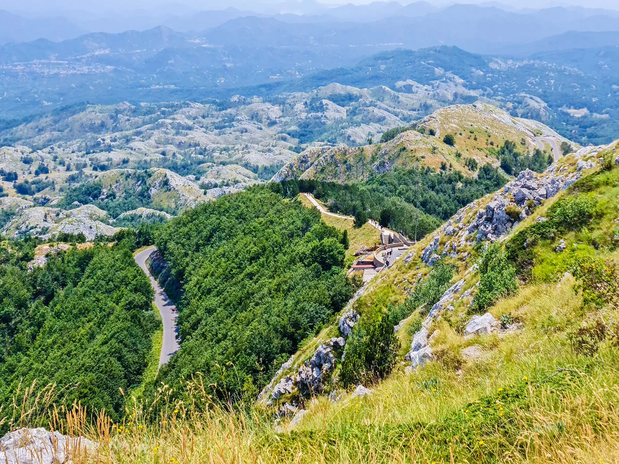
Durmitor

In the northwest of the country, above the town of Žabljak, rises Durmitor, a mountain that combines the harshness of high rock faces with the softness of glacial lakes. Its highest peak, Bobotov Kuk, reaches two thousand five hundred and twenty-three meters and towers over a stunning landscape. What makes it one of the most beautiful massifs is the dramatic contrast between deep canyons such as the Tara River and the calm blue lakes nestled in green valleys, with panoramic views stretching across the northern region.


Planinske oči Durmitora, Zmijsko jezero, Valovito jezero, Modro jezero, Zminičko jezero, Suha lokva, Zeleni vrtlog, jezero Sušice, Barno jezero, Zabojsko jezero, jezero Srable, jezero Jablan, Vražje jezero, Ševarita lokva, Veliko Škrko jezero, Malo Škrčko jezero, Riblje jezero, Pošćensko jezero, Žabljak, Crno jezero, Durmitor, nacionalni park Durmitor, najveći nacionalni park u Crnoj Gori, kanjon Nevidio, rijeka Komarnica, rijeka Draga, rijeka Piva, kanjon rijeke Drage, kanjon rijeke Pive, kanjon  Sučice, kanjon rijeke Tare, vodopad Skakala, Sušičko jezero, najveći kanjon u Crnoj gori, Ledena pećina, Ledena špilja, Ledena špilja Durmitor, Bobotov Kuk, najviši vrh Durmitora, durmitor wikipedia, ime durmitora, recenzije durmitora, značenje durmitora, nacionalni park durmitor, durmitor žabljak, durmitor planina, durmitor činjenice, činjenice o durmitoru, durmitor činjenice wikipedia, durmitor zanimljivosti, zanimljivosti o durmitoru, Zmijsko  lake, Volovito lake, Modro lake, Zminičko lake, Suha klova, Zeleni vrtlog, Sušica lake, Barno lake, Zabojsko lake, Srable lake, Jablan lake, Vražje lake, Ševarita lokva, Big Škrko lake, Small Škrčko lake, Riblje lake, Pošćensko lake, Mountain eyes of Durmitor, Zmijsko lake, Volovito lake, Blue lake, Zminičko lake, Dry puddle, Green vortex, Sušice lake, Barno lake, Zabojsko lake, Srable lake, Jablan lake, Vražje lake, Ševarita klova, Veliko Škrko lake, Malo Škrčko lake , Fish Lake, Pošćensko Lake, Žabljak, Black Lake, Durmitor, Durmitor National Park, the largest national park in Montenegro, Nevidio Canyon, Komarnica River, Draga River, Piva River, Draga River Canyon, Piva River Canyon, Sučica Canyon, River Canyon Tare, Skakala waterfall, Sušičko lake, the largest canyon in Montenegro, Ice cave, Ice cave, Ice cave Durmitor, Bobotov Kuk, the highest peak of Durmitor, durmitor wikipedia, name of durmitor, reviews of durmitor, meaning of durmitor, national park durmitor, durmitor žabljak, durmitor mountain, durmitor facts, facts about durmitor, durmitor facts wikipedia, durmitor interesting facts, interesting facts about durmitor,

Durmitor, Photo: Nick Savchenko, CC BY-SA 2.0

Prokletije

In the far southeast of the country, near the borders with Albania and Kosovo, rise the Prokletije Mountains, a massif with the steepest and most dramatic relief in Montenegro. Zla Kolata, at two thousand five hundred and thirty-four meters, is the highest peak in the country. This massif stands out for its alpine silhouette, snow-covered peaks, and sheer rock walls that look as if they were cut from another continent. Prokletije are remarkable for their unusual geological structure, sharp ridgelines, and sudden sense of scale as you approach them from the valleys.


Montenegro, Bobotov Kuk, Mount Durmitor, Maja Rozit, Prokletija, Yearbook of Monstat, Montenegro, Prokletije, Albania, Zla Kolata, Dobra Kolata, the highest peak, higher mountain peaks, Maja e Roshit, Crna Gora, Bobotov Kuk, Durmitor, Maja Rozit, Prokletija, Godišnjak Monstata, Crna Gora, Prokletije, Albanija, Zla Kolata, Dobra Kolata, najviši vrh, viši planinski vrhovi,

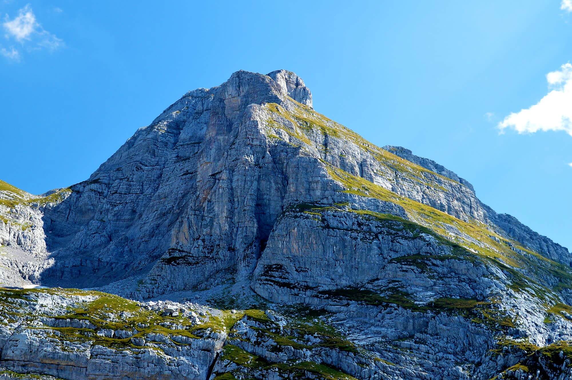
Zla Kolata, Prokletije, Montenegro, Photo: Pavouk


Komovi

East of Kolašin, between the rivers Tara and Lim, lies the Komovi massif, known for its three dominant peaks. Kom Kučki, Kom Vasojevićki, and Kom Ljevorečki are all higher than two thousand four hundred meters and together form an almost perfect natural amphitheater. The beauty of Komovi lies in the harmonious blend of grassy slopes and rocky ridges, with clearly defined outlines standing out against the sky. The clean form, defined terrain, and openness of the horizon make it one of the most visually appealing massifs in the country.


Montenegro, Komovi, mountain range, Komovi mountain range, Komovi mountain massif, Kukački Kom, Ljevoriječki Kom, Vasojevički Kom, Lim river, Tara river, Prokletije Mountains, monastery of St. George, Eko katun Štavna, Komovi Nature Park, Komovi mountains, Komovi National Park, Hiking in Komovi, Komovi trails, Camping in Komovi, Wildlife in Komovi, Komovi peak, Komovi accommodation, Komovi trekking, Komovi landscape, Explore Komovi, Komovi adventure, Komovi tourism, Komovi travel guide, Best time to visit Komovi, Things to do in Komovi, Komovi photos, Komovi weather, Komovi nature reserve, Komovi biodiversity, Crna Gora, Komovi, planinski lanac, vijenac Komova, planinski masiv Komova, Kukački Kom, Ljevoriječki Kom, Vasojevički Kom, rijeka Lim, rijeka Tara, Prokletije, manastir Svetog Đorđa, Eko katun Štavna, Park prirode Komovi, Komovi, Nacionalni park Komovi, Planinarenje Komovima, staze Komova, Kampovanje Komova, Divlje životinje Komova, Vrh Komovi, Smještaj Komovi, Planinarenje Komovima, Komovi pejzaž, Istražite Komove, Komovi avantura, Komovi turizam, Komovi turistički vodič, Najbolje vrijeme za posjet Komovima, Što raditi u Komovima, fotografije Komova, vrijeme Komova, prirodni rezervat Komovi, bioraznolikost Komova,

Komovi, Photo: master78, Depositphotos


Bjelasica

Bjelasica is located between the towns of Kolašin, Mojkovac, and Bijelo Polje. Unlike other Montenegrin massifs, it was formed through volcanic activity, which gives it a distinct, rounded terrain and rich vegetation. Its highest peak, Crna Glava, reaches two thousand one hundred and thirty-nine meters. What makes Bjelasica unique is its coverage of lush green pastures and dark forests, with lakes shimmering between gentle hills. The colors and shapes here are soft and pleasant, and thanks to its easy access from Kolašin, it is one of the most approachable mountain areas in the country.


Tara, Lim, Bjelasica Mountain, Montenegro, Kolašin, Kolasin ski resort, most famous ski resorts in Montenegro, Biogradska Gora National Park, Biogradsko Lake, Pešića Lake, Big Ursulovacko Lake, Small Ursulovacko Lake, Big Šiško Lake, Small Šiško Lake, Lake Biograd, last virgin forests in Europe, Tara river, rafting on Tara river, rafting Biogradska Gora National Park,  Tara, Lim, Bjelasica, Crna Gora, Kolašin, skijalište Kolašin, najpoznatiji skijaški centri u Crnoj Gori, Nacionalni park Biogradska Gora, Biogradsko jezero, Pešića jezero, Veliko Ursulovačko jezero, Malo Ursulovačko jezero, Veliko Šiško jezero, Malo Šiško jezero, Jezero Biograd, posljednje prašume u Europi, rijeka Tara, rafting na rijeci Tari, rafting Nacionalni park Biogradska Gora,

Bjelasica, Photo: Matěj Baťha, CC BY-SA 3.0


Lovćen

Above the Bay of Kotor, between the coast and the interior, rises Lovćen. Its highest peak, Štirovnik, reaches one thousand seven hundred and forty-nine meters, while the slightly lower Jezerski Vrh is home to the mausoleum of Petar II Petrović Njegoš. Lovćen is visually striking because it rises directly above the sea, offering views that stretch across the entire bay, Skadar Lake, and inland Montenegro. Nowhere else in the country does nature create such a sharp contrast between the sea and the mountains.


Montenegro, Boka Kotor Bay, Cetinje, National Park Lovcen, Štirovnik, Stirovnik, highest peak of Lovcen, Mount Lovcen, black mountain,  Cetinje, Kotor, Jezerski Vrh, Njegos Mausoleum, Best view of Kotor, Horizont Bar Montenegro Crna Gora, Bokokotorski zaljev, Cetinje, Nacionalni park Lovćen, Štirovnik, najviši vrh Lovćena, planina Lovćen, crna planina,  Cetinje, Kotor, Jezerski Vrh, Njegošev mauzolej, Najbolji pogled na Kotor, Horizont Bar Crna Gora

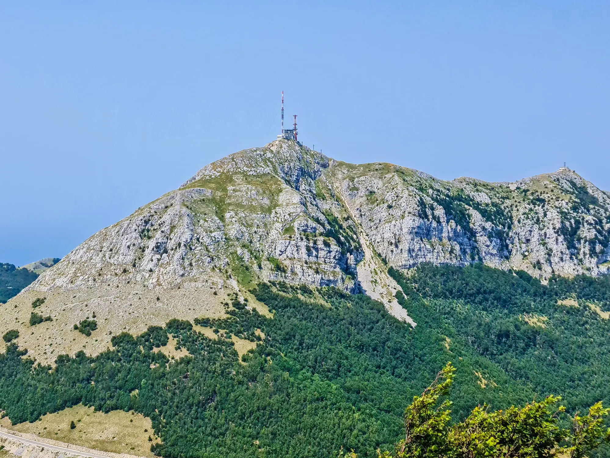
Štirovnik, NP Lovćen, Photo: Adria.fun


These massifs are not only the highest and most well-known. They are the most diverse in shape, color, accessibility, and visual impact. If you want to experience landscapes that change with every few steps and views that never grow old, these five mountains offer the perfect introduction to what Montenegro truly is.


Ads
author

Peace, love and music! ☮️

Leave a Reply

Your email address will not be published. Required fields are marked *